A creek-valley approach to a bookable alpine cabin, with longer excursions into meadows, lakes and surrounding mountain terrain.
Sources reviewed . This is a research date, not a trail inspection.
Check access before you leave
Dore River road access: closed bridge; reopening not verified
The provincial page updated October 8, 2026 still lists the Dore River Branch 1 bridge at kilometre 2.1 as closed with a zero-tonne load rating. The same page announced replacement work for the week of August 17 and expected two to three weeks of construction, but does not confirm reopening. These overlapping notices leave the current outcome unresolved. Confirm reopening with the road authority before relying on access beyond this bridge.
Not establishedThe source lists 500 m with the outward route. Any climbing on the return is not established; this is not a verified complete-return total.
Walking time
Not published
Difficulty
Not rated
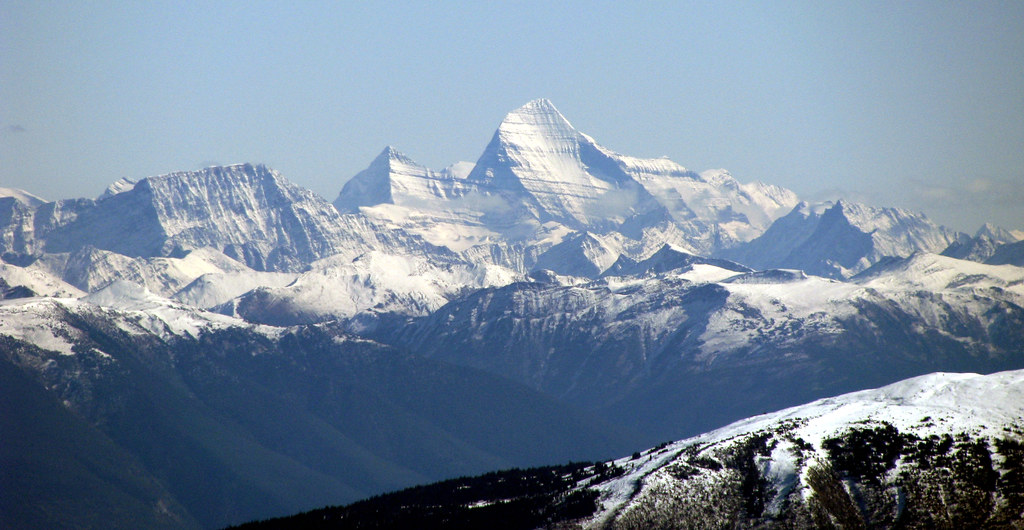
Mount Robson across the Rocky Mountain Trench, viewed from the Ozalenka Valley area on 11 October 2009.East to the King (opens original source) · Dru! · CC BY-NC 2.0 (opens original source) · 2009-10-11. Downloaded provider display size; no local image edits. Display may crop the view. · Noncommercial only
Map & elevation
Opening the map…
Partial elevation profile
Mapped portion · walking direction unconfirmed · 6.68 km
This chart covers only part of the route. It does not establish the full hike or a return journey.
Coverage and elevation sources
6.68 km along source section 1 of 1, in its mapped direction. Approximate 90 m terrain model along this mapped section. Separate sections are not joined. This chart does not measure total trail ascent or establish current access; use the guide’s published outing measurements.
Mapped named trail. Shows the named source trail. The full published outing, return journey and current on-the-ground alignment are not independently established by this line. Line source (opens original source).
Getting there & parking
Access alert: the Dore River bridge at road kilometre 2.1 is listed as closed, and a reopening has not been verified. Confirm the road authority’s current status before using the approach below. From Highway 16 about 5 km west of McBride, turn onto Dore River Road and continue onto Dore River Forest Service Road. At the first major junction, about 6 km along the forest-road approach in the tourism description, take the right branch signed for Ozalenka. Continue approximately 8 km, take the next right toward Ozalenka, and drive about 4 km farther to the trailhead. A porcupine enclosure is described at the parking area. Forest-road distances vary slightly between published guides; follow current Ozalenka signs and confirm road access with the cabin operator.
Map position: 53.25736, -120.40956 · source-published trailhead / parking area. PROJECT_NAME=Ozalenka trailhead and Parking Area; FOREST_FILE_ID=REC1473; official source point [-120.40956120027549, 53.25736043410624]
On the trail
Begin by crossing the river near the trailhead, then follow the established route up Ozalenka Creek to the cabin, roughly 7 km one way. The cabin is the normal valley destination and a base for further exploration, not the end of all possible walking in the area. Open meadows, lakes and higher peaks lie beyond, but require a separate route choice and more time. Return on the same valley trail unless you have planned a distinct backcountry trip. The tourism page describes a replacement two-storey cabin completed in autumn 2022.
Conditions & seasons
The cabin supports both summer and winter visits. Summer road access, winter approach length, snow conditions and avalanche exposure need separate planning; the summer 7 km trail distance does not establish a complete winter trip length.
These are dated research notes. Open the trip planner for current available weather and advisory feeds; no alert found does not establish that a trail or road is open.
The Ozalenka campground is first come, first served. The cabin is a separate reserved accommodation managed by the Ozalenka Alpine Club. BC Parks also permits wilderness camping without facilities elsewhere inside West Twin Park. The unresolved Dore River bridge closure still affects access to this overnight trip.
Descriptions are written for this guide from the linked evidence. Source review dates, published reports and field observations can differ. Photographs and route lines retain their own attribution and reuse terms.