A substantial forest loop circles Morfee Lake, with connections to beaches, the narrows and a separate Morfee Falls branch. It is a longer walk than a quick visit to the waterfront.
Sources reviewed . This is a research date, not a trail inspection.
Not establishedCumulative ascent for this outing has not been established.
Walking time
Not published
Difficulty
Not ratedloop
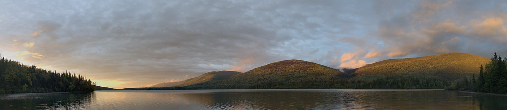
Morfee Lake near Mackenzie, photographed on 16 September 2013. This panorama shows the lake landscape, not the entire perimeter route.Morfee Lake panorama (opens original source) · shootfirstthinklater · CC BY-NC 4.0 (opens original source) · 2013-09-16. Provider display size downloaded; no local edits. Display may crop the view. · Noncommercial only
Map & elevation
Opening the map…
Elevation profile
A full-route elevation profile is not available yet. The mapped paths have not been verified as one continuous outing.
Choose a specific route where available. Individual map fragments are not shown as separate hike stages.
More maps & trail files
AllTrails map
Morfee Lake circuit on AllTrails
The hosted map shows about 15.7 km around Morfee Lake, including an eastern side spur. This much longer circuit is distinct from the direct Morfee Falls return; overlapping paths do not make the outings interchangeable.
Mapped trail network. The named lake sections are a network with branches. They are not treated as one continuous perimeter itinerary. Line source (opens original source).
The loop can be entered from Morfee Lake Road near the campground or from Morfee Mountain Road. For the latter, go north 2.1 km from McIntyre Drive on Mackenzie Boulevard, turn right onto Morfee Mountain Road and continue 1.7 km to the second bridge. The path starts on the right before the bridge; use a suitable pullout without blocking road access. Choose the entry before planning distance, because campground and road starts join different parts of the circuit.
Map position: 55.34861, -123.07639 · named destination reference point (not a trailhead). BC Gazetteer: Morfee Lakes; Lakes; 55 20 54 N, 123 04 35 W; WGS84.
Published named-feature location for regional orientation and weather. Does not mark trailhead parking or a specific route viewpoint.
On the trail
Enter the perimeter path on the right before the bridge.
After about 3 km, stay left past the right-hand narrows spur.
A few hundred metres later, take the right branch to remain on the lake circuit; left leaves toward Morfee Falls.
Full route notes
Follow the perimeter route around the lake, using the local map to stay on the lake circuit at branch junctions. From the Morfee Mountain Road start, a right branch to the narrows appears after about 3 km. Continue past it to the next junction: keep right for the perimeter loop, while the left branch leaves for Morfee Falls. Forest sections include exposed roots and rock, and the falls approach is a separate wet hillside extension. Published lake-loop lengths are approximately 15–15.8 km; adding the waterfall visit increases the outing. Return to your original entrance rather than following a beach access that ends at a different parking area.
The way back
Continue only with the full perimeter map available and return to the original entrance. The published loop is about 15 km; the falls branch adds distance and is not part of the basic circuit.
Conditions & seasons
Season-specific access has not been established in this guide. Read the dated notices and original land-manager information before choosing a departure date.
These are dated research notes. Open the trip planner for current available weather and advisory feeds; no alert found does not establish that a trail or road is open.
On-route camping permission has not been established for this outing. Check the relevant land manager before planning an overnight stay; a mapped lake, cabin or previous tent location does not confirm permission.
Photos of Morfee Lake Perimeter
Morfee Lake near Mackenzie, photographed on 16 September 2013. This panorama shows the lake landscape, not the entire perimeter route.Morfee Lake panorama (opens original source) · shootfirstthinklater · CC BY-NC 4.0 (opens original source) · 2013-09-16. Provider display size downloaded; no local edits. Display may crop the view. · Noncommercial only
Original photo galleries
These galleries stay on their photographers’ original websites.
Descriptions are written for this guide from the linked evidence. Source review dates, published reports and field observations can differ. Photographs and route lines retain their own attribution and reuse terms.