Skip to guide
northward.NORTHERN BRITISH COLUMBIA
Waterfalls · Tumbler Ridge & Monkman · Tumbler Ridge / Monkman / Peace Rockies

Bergeron Falls

Upper views and a longer circuit explore different parts of the canyon. Water crossings and cliff exposure make the circuit more demanding.

Sources reviewed . This is a research date, not a trail inspection.

Distance
12 kmLoop
Elevation gain
450 mPublished route measurement
Walking time
5–7 hours
Difficulty
Not rated
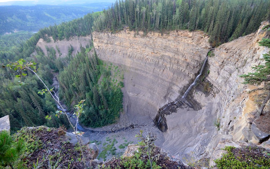
Bergeron Falls and the canyon below
Bergeron Falls and the canyon below, photographed on 26 August 2014. Water flow varies through the season.Bergeron Falls - Tumbler Ridge, British Columbia, Canada. (opens original source) · Miles Green · CC BY 2.0 (opens original source) · 2014-08-26. Provider resized the original for this download; no local edits. Display may crop the view.

Map & elevation

Opening the map…

Elevation profile

A full-route elevation profile is not available yet. The mapped paths have not been verified as one continuous outing.

Choose a specific route where available. Individual map fragments are not shown as separate hike stages.

More maps & trail files

Mapped trail network. The waterfall, cliffs and connector are a linked trail network. The source lines do not select one of the possible loop or return itineraries. Line source (opens original source).

Original map 1 (opens original source)

Getting there & parking

Drive north from Tumbler Ridge on Highway 29 toward Chetwynd for about 6.5 km. Turn right onto the signed gravel access road and follow it roughly 8 km to its end beside a large gravel pit. The hiking sign marks the common start for the falls and cliffs routes.

Map position: 55.17772, -120.99310 · trailhead. The WNMS Directions to Trailhead link points to Bergeron Falls and Cliffs Trailhead. Position uses the place coordinates, not the map viewport centre.

On the trail

  1. At the first fork, about 600 m from parking, take the right branch toward the falls.

  2. At about 2.2 km, the left branch leads to the upper-viewpoint return option; the full circular outing takes the right branch.

  3. For the circular outing, descend toward the Murray River and cross the creek only if conditions permit. After the crossing, the right-hand bypass avoids the scrambling canyon line; about 200 m uphill a signed left spur leads toward the falls base.

  4. Return from the base spur to the circular trail and climb to the upper viewpoints before returning on the common approach.

Full route notes

From the parking lot, follow the gently climbing forest path and take the right branch at the first fork around 600 m; the left branch goes toward Bergeron Cliffs. Pass Vomer Creek and its small side waterfall, then follow the forest cutline to the major route choice around kilometre 2.2. For the simpler upper-falls out-and-back, keep left, cross Bergeron Creek on the footbridge and continue to the upper viewpoint benches. Respect the barrier at the unstable old viewpoint and turn back before the descent if this is your chosen outing. The much harder circular route takes the right branch at kilometre 2.2, descends toward the Murray River and includes creek crossings, narrow ridges and steep climbing back from the falls base. Its canyon spur requires low water and scrambling; high water can make the circular route impassable. The upper-viewpoint hike and the full circuit must retain separate metrics and difficulty.

The way back

The circuit includes four creek crossings and can be impassable in high water. The simpler upper-viewpoint route returns from its final bench and does not continue down into the circuit.

Terrain: exposure · creek crossings · gravel.

Distance and elevation source notes

Source comparison: Upper viewpoints; 8.8 km; return scope. Same viewpoint or falls loop with a different source estimate; the physical route is already represented.

Source comparison: Circular route with base spur; 11.5 km; loop scope. Same viewpoint or falls loop with a different source estimate; the physical route is already represented.

Source comparison: Circular route including falls base; 12 km; 450 m ascent; 5–7 hours duration; loop plus spur scope. Same viewpoint or falls loop with a different source estimate; the physical route is already represented.

Conditions & seasons

Spring flow can make the waterfall impressive while also making the lower route’s crossings unsafe. The circular route has four creek crossings and unguarded drops. Choose the upper-viewpoint option if the lower crossings are not safely passable; a dry forest start does not establish safe creek levels farther on.

These are dated research notes. Open the trip planner for current available weather and advisory feeds; no alert found does not establish that a trail or road is open.

Check weather & available updates →

Camping & overnight plans

On-route camping permission has not been established for this outing. Check the relevant land manager before planning an overnight stay; a mapped lake, cabin or previous tent location does not confirm permission.

Photos of Bergeron Falls

Bergeron Falls and the canyon below
Bergeron Falls and the canyon below, photographed on 26 August 2014. Water flow varies through the season.Bergeron Falls - Tumbler Ridge, British Columbia, Canada. (opens original source) · Miles Green · CC BY 2.0 (opens original source) · 2014-08-26. Provider resized the original for this download; no local edits. Display may crop the view.
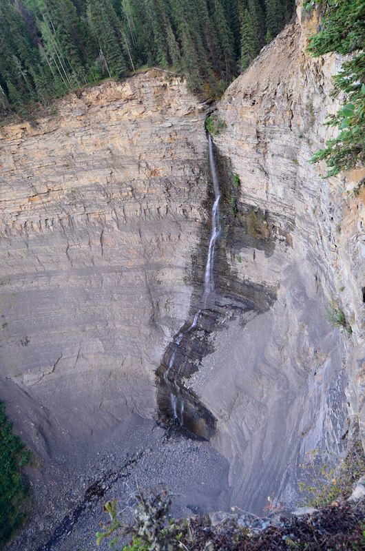
Bergeron Falls descending the cliff
Bergeron Falls descending the cliff on 26 August 2014.Bergeron Falls - Tumbler Ridge, British Columbia, Canada. (opens original source) · Miles Green · CC BY 2.0 (opens original source) · 2014-08-26. Provider resized the original for this download; no local edits. Display may crop the view.

Take this guide with you

Choose a trip pack or an available individual sheet for your map case.

Sources, dates & research notes

Descriptions are written for this guide from the linked evidence. Source review dates, published reports and field observations can differ. Photographs and route lines retain their own attribution and reuse terms.
  1. https://investtumblerridge.ca/wp-content/uploads/2018/11/TR_Map_insert2018_web.pdf (opens original source)
  2. https://www.wnms.ca/trail/bergeron-falls (opens original source)
  3. https://assets.wnms.ca/brochures/bergeron-falls-jan-2025.pdf (opens original source)
OpenStreetMap line references (18)

These contributor-mapped features support the map geometry. They are separate from the written access and route sources.

  1. https://www.openstreetmap.org/way/197475935 (opens original source)
  2. https://www.openstreetmap.org/way/643612144 (opens original source)
  3. https://www.openstreetmap.org/way/643612145 (opens original source)
  4. https://www.openstreetmap.org/way/643612146 (opens original source)
  5. https://www.openstreetmap.org/way/1556848385 (opens original source)
  6. https://www.openstreetmap.org/way/1556848386 (opens original source)
  7. https://www.openstreetmap.org/way/1556848387 (opens original source)
  8. https://www.openstreetmap.org/way/1556848388 (opens original source)
  9. https://www.openstreetmap.org/way/1556848389 (opens original source)
  10. https://www.openstreetmap.org/way/1556848390 (opens original source)
  11. https://www.openstreetmap.org/way/1556848391 (opens original source)
  12. https://www.openstreetmap.org/way/1556848392 (opens original source)
  13. https://www.openstreetmap.org/way/1556848393 (opens original source)
  14. https://www.openstreetmap.org/way/1556848394 (opens original source)
  15. https://www.openstreetmap.org/way/1556848395 (opens original source)
  16. https://www.openstreetmap.org/way/1556848396 (opens original source)
  17. https://www.openstreetmap.org/way/1556848397 (opens original source)
  18. https://www.openstreetmap.org/way/1556848398 (opens original source)
Details still being researched
  • No on-route/designated camping permission verified.

Nearby and related guides